
Poplar Bluff is nestled in a perfectly central location, encompassed by the idyllic scenic beauty of Southeast Missouri! Get outdoors and explore our backyard with us. We know you’re going to love it!
Click Here for a Poplar Bluff Parks and Trails Map
Featured Video:
Learn More
Recreation & Outdoors
* = Member of the Poplar Bluff Chamber of Commerce
 Black River Coliseum Aquatic Center*
301 S. 5th Street, Poplar Bluff, MO | (573) 686-8001
Website
Membership Rates: Family memberships consist of anyone living in the household with proof of residency.
*If the amount of members of a family exceeds 5, then the family membership will increase $2.00 per member a month.
 Disc Golf at our Poplar Bluff Parks!
Click Here for a full Parks & Trails Map
Disc Golf is a fun game in which a concave plastic disc is thrown into each of a series of metal baskets situated on an outdoor course, the object being to complete the course in as few throws as possible! Poplar Bluff has multiple options for you and your family to get outdoors and enjoy a game:
Kiwanis Bacon Memorial Park
Between the 1300 block of West Pershing and 1400 block of West Harper Streets.
Course Map
Hendrickson Park
1180 Davis Street, Poplar Bluff, Missouri
Course Map

Downtown Poplar Bluff Dog Park
Downtown Poplar Bluff
Facebook Page | Website
Fenced in, off leash area where well behaved canine citizens can exercise in a clean, safe environment that is open to all.
.
.
.
 Bricks Off Road Park*
2181 County Road 484, Poplar Bluff, MO 63901 | (573) 718-7388
www.bricksoffroadpark.com
Brick’s Off Road Park is open to any and all types of off-road vehicles from 4-Wheelers, to dirt bikes, to dune buggies, it even has some technical up hill and rock climbs for the experienced Rock Crawlers. Bricks is open on specific weekends throughout the year with primitive camping available for $20/night for up to 8 people. This to a fun family place to challenge your muddin’ vehicle in the beautiful southeast Missouri Ozark foothills. For full information go to our website and let’s get muddin’!
 Forum Fifty Fifty
413 Vine Street, Poplar Bluff, MO | (573) 429-3775
Website | Facebook Page
Forum Fifty Fifty is a music venue/event space and indoor skate park and skate shop.
 Smids Mini Golf
8816 Hwy T, Wappapello, MO | (573) 429-3614
Facebook Page
Smids Mini Golf is open Friday, Saturday, and Sunday. They also have a huge yard sale in their big building every weekend. Bring the whole family for a fun day out!
 Big Spring
Van Buren, MO 63965 | (877) 444-6777
Website
Big Spring was one of Missouri’s first state parks. It was a state park from 1924 until 1969 when the people of Missouri donated it, along with Alley and Round Spring State Parks to the National Park Service to become a part of the Ozark National Scenic Riverways. A gift from Missouri to America.
The Big Spring area contains the Big Spring of course, but also a campground, a picnic area, a dining lodge, trails and housekeeping cabins. It is easily located four miles south of Van Buren at the end of State Route 103.
Big Spring Campground has sites for tents as well as RVs. Some have electric hook-ups and some do not. There are no water or sewer hook-ups, but a dump station is located nearby. During the warmer months reservations are recommended for electric sites. www.recreation.gov or call 877-444-6777. Rangers present campfire programs on weekend evenings in the campground amphitheater during the summer. Various special events are held near the spring as well.Check out our calendar page for details on special events.
Picnic Areas are located throughout the area, with tables and grills. There are two picnic shelters, Big Spring Shelter, located near the Spring and Peavine Shelter, located near the campground, that can be reserved. www.recreation.gov or call 877-444-6777.
Big Spring Lodge and nearby cabins are wonderful examples of Depression era architecture. Built by the Civilian Conservation Corps they are still solid and in use today. The Lodge and CCC Cabins are currently closed due to much needed renovations. For the latest information on the restoration of the Big Spring Lodge and Cabins.
![]() Clearwater Lake
Clearwater Lake
Piedmont, MO 63967 | (573) 223-7777
Website
The US Army Corps of Engineers completed construction of the Clearwater Lake Dam in 1948, with the prime purpose of maintaining flood control for the Black River drainage around the Poplar Bluff region. At a conservation pool of 1,630 acres, the lake is a great size for recreational and fishing boats up to 30’ long, with a keel depth of 1.5’ or less. At maximum flood level, the lake increases over 6 times in size to 10,350 acres. The Corps of Engineers maintains a summer pool at 498’, and a winter pool at 494’. For the current water levels, the USGS maintains water level monitors, which can be accessed here.
What to do at Clearwater Lake:
While not the largest of lakes, Clearwater still has plenty to offer the visitor. Fishing is primarily focused on the spring and winter spawn, and crappie and catfish during the summer months. A great resource for the fisherman can be found here. The Corps periodically drops trees in the lake to provide fish habitat. A map of the brush areas can be found here. If fishing up the Black River, it is best to have a jet prop due to the shallow water levels above the Bluff View Area. The Logan and Webb Creek branches are shallow as well, it would be wise to check in with the local marinas to get their input on the current fishing conditions.During the summer months the lake becomes a recreational playground, with boating enthusiasts hitting the water primarily during the weekends. Pulling water toys, skiing, wake boarding, and knee boarding are popular activities that elicit shrieks of glee on all areas of the lake. The weekday visitor can find that the lake is quite peaceful and not quite as busy. Most of the dedicated fishermen leave the lake to the “weekenders” then hit the fishing holes during the weekdays.When visitors tire of the waters, there are still many activities that can make for pleasurable days. The Corps maintains several hiking trails around the lake, and a biking trail at the River Road campground. Also at the River Road campground is a tournament volleyball pit, as well as basketball courts, playgrounds, and a great view of the spillway. Golfing enthusiasts can visit the Canyon Club Golf Course in Piedmont, while hikers can visit the nearby Lon Sanders Canyon Conservation Area for a scramble over the shut-ins of McKenzie Creek.At night time, the casual visitor only has to gaze upwards to see sights that are simply not available in the big towns as the Milky Way comes out to dance in the skies. A popular time to visit is during August 11-13 to view the biggest celestial event of the year – the Perseid Meteor Shower. With upwards of 100 meteors per hour, the clear skies of Clearwater Lake makes for a memorable evening.
 Current River
Van Buren, MO
Website
The Ozark National Scenic Riverways protects 134 miles of the Current and Jacks Fork Rivers and some 80,000 acres of river, forest, open field and glade environments. Riparian habitats are a major component of the park. Typified by sycamores, maples, cottonwoods and willows, floodplain forests line the rivers. These provide habitat for Swainson’s warblers, wood ducks, great blue herons and a wide variety of other species. As a significant karst resource, the park contains the world’s largest collection of first magnitude springs.
 Mingo National Wildlife Refuge*
Puxico, MO | (573) 222-3589
Website
When the last of the glaciers retreated over one million years ago, the mighty Mississippi River carved its way through the area we call Mingo National Wildlife Refuge. Although the primary purpose of the over 21,000 acres is to provide food and shelter for migratory waterfowl, the refuge is open for hiking, canoeing, fishing and nature study. The refuge is the only large tract of bottomland forest left in the bootheel of Missouri. The Mingo swamp was formed about 18,000 years ago when the Mississippi River shifted to the east, leaving a dense swamp to form in its abandoned channel.
 Mark Twain National Forest
1420 Maud Street, Poplar Bluff, MO | (573) 785-1475
Website
The Poplar Bluff Ranger District, headquartered in Poplar Bluff, Missouri contains 150,000 acres open to the public for hiking, camping, hunting, bird watching, bike riding and canoeing. The District is well know for its fall foliage. The Poplar Bluff Ranger District manages several developed recreation areas: Pinewoods Lake is one mile west of Ellsinore, Missouri on Highway 60. Camping, picnicking and fishing are permitted here. Markam Springs Recreation Area, located three miles west of Williamsville, Missouri on State Route 49, is a concession operated area providing hiking, camping, picnicking and boat access to Black River. The newest Recreation Area in the Poplar Bluff Ranger District is the Hendrickson Boat Launch and Trailhead. Located ten miles north of Poplar Bluff on Highway 67, this facility provides boat access to the river pools near the Williamsville Stone Plant.
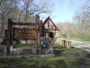 Sam A. Baker State Park
Route 1 Box 113, Patterson, MO | (573) 856-4411
Website
It only takes a few minutes to fall in love with Sam A. Baker State Park. The cool waters of the St. Francois River and Big Creek frame a wooded setting with trails that range from easy to challenging. Ancient mountains, towering trees, and fresh air are hallmarks of the park. Rustic cabins, a campground, a separate campground for equestrians, and a lodge with good country cookin’ round out the Sam A. Baker experience. With over 5,000 acres, Sam A. Baker is one of the oldest parks in the Missouri state park system. It offers visitors opportunities for camping, canoeing, fishing, and foot and horseback riding trails.
 Wappapello Lake – U.S. Army Corps of Engineers
10992 Highway T, Wappapello, MO | (573) 222-8562
Lake Stage Information: 573-222-8139
Lake Wappapello Corps of Engineers
Nestled in the foothills of the Ozark Mountains, the U.S. Army Corps of Engineers at Wappapello Lake offers activities for all walks of life. Several annual special events are held at the lake, such as the Old Greenville Black Powder Rendezvous, Intertribal Living Indian Village, Disabled Persons Fishing Day, Annual Drag Boat Races, Waterfest, Old Greenville Days and the Festival of Lights. Wappapello Lake has over 44,000 acres of public lands and water, which welcome hunting, fishing, swimming, boating, camping and picnicking.
 The Camp at Lake Wappapello*
153 University Forest Drive, Wappapello, MO | (573) 222-2267
Website | Facebook Page
Located along the Southern border of Southeast Missouri’s Wappapello Lake, The Camp at Lake Wappapello is set on 160 acres of wilderness and is designed to let you enjoy the comfort of your own home while still giving you easy access to campground amenities and proximity to all kinds of exciting outdoor destinations. During the summer, you can expect the concert venue to be full with both great local talent and out of town acts. Sit back and enjoy the shows under their covered venue with drink and bar stations placed around the area to provide a quick drink without missing a beat.
 Rocky Falls
National Scenic Riverways, Missouri | (573) 323-4236
Website
Few places in the Ozarks provide a glimpse of earth’s turbulent past as well as Rocky Falls. The reddish-brown rock you see here is rhyolite porphyry. It formed as molten rock deep within the earth and flowed onto the surface about 1.5 billion years ago. At the time, no living thing existed to see the awesome flow of glowing hot lava slowly advancing over the barren landscape. Normally, a stream eroding softer dolomite, a type of limestone, would make a wider valley for itself. Since the rhyolite is harder, the stream tends to stay within whatever cracks that it finds, deepening them only a little by erosion. Thus a“shut in” is formed where the harder rock has “shut in” the stream. Farther downstream, past the constricting rhyolite, the stream valley widens once again. This allows the stream to expand into a pool. Rocky Falls can be visited year round. It is located on Route NN, off of Route H east of Eminence and Winona. It has a walking trail, bathrooms, picnic tables and fire grills.
 Missouri Department of Conservation
Hunting & Fishing
www.mdc.mo.gov
Hunting/Trapping
Fishing
Permits
Public Access Conservation Areas
Peck Ranch Elk herd
Otter Slough
Mingo Wildlife Area
Other Area State Parks
Education
Missouri Department of Conservation Nature Shop
US Army Corps of Engineers: Lake Wappapello Corps of Engineers
US Fish and Wildlife Department: www.fws.gov 800-344-9453
US Forestry Service: www.fs.fed.us

Peck Ranch Conservation Area
Click here for more information | Website
View Missouri’s recently restored elk herd, fall color, spring flowering trees and an Ozark woodland from your car.At Peck Ranch you can also go hiking, fishing, camping, bird watching/feeding, bicycling, and so much more!
To give you a chance to see some of Missouri’s first free-ranging elk in nearly 150 years, we’ve set up a self-guided driving tour at Peck Ranch Conservation Area.
The route begins at the Peck Ranch office and is marked along the way. Peck Ranch is located near Winona in Shannon County with entrances off both Route 19 and Route 60. Peck Ranch is open sunrise to sunset seven days a week–except during managed deer hunts, fall firearms deer season and in the event roads are closed due to weather.
Your best chances of seeing elk are the hours right after sunrise or right before sunset. We can’t guarantee an elk sighting, but the tour is a beautiful drive though fields, forests and glades where you can also see deer and other wildlife.
Feel free to take photographs, and get out of your vehicle if needed for a better view, but please do not disturb elk or other wildlife in any way.
Note that the gravel roads on Peck Ranch may not be accessible to vehicles without adequate ground clearance, and some roads may also be impassible at times due to high water at stream crossings.
 Alley Spring / Alley Mill
Six miles west of Eminence, MO on State Route 106 | (573) 323-4236
Website
The rolling, forested landscape around Alley Spring is where two of America’s most beautiful spring-fed rivers combine to make up the Ozark National Scenic Riverways. As the first national park area to protect a wild river system, visitors are able to enjoy various water activities as well as hiking, horseback riding and wildlife viewing. Offers a family campground with 162 campsites along the Jacks Fork River in the Ozark National Scenic Riverways. Only two blocks to Alley Mill, Alley General Store, and Story’s Creek One Room Schoolhouse. Park rangers lead hikes and campfire programs during the summer.
 Missouri’s Wild Horses
Often spotted around the Eminence, Jacks Fork, and Current River areas
Dozens of wild horses roam freely between the Jack’s Fork and Current River areas. If they’re lucky floaters or paddlers along these rivers might just catch a glimpse of them. These horses have been roaming free for more than 100 years and were the subject of a Supreme Court battle in the 1990’s in which they were nearly removed. Ultimately President Bill Clinton signed the bill into law on October 3, 1996, granting them the federal protection they have today. Locals share that some of the best places for viewing are the Broadfoot Fields, located north of Eminence, the Shawnee Fields, east of Eminence, or the fields above the two Rivers on Hwy V.
 Keener Springs
3425 State Hwy JJ, Williamsville, MO 63967 | (573) 998-3211
Website
Located just 15 minutes north of Poplar Bluff, Keener Springs is one of the largest privately-owned springs in the country emitting 28,000,000 gallons per day! The 65 acre property is nestled on the banks of beautiful Black River with the Spring Pond and unique, water-filled cave as the focal points.
The spring and the unique, water-filled cave are the focal points of the 65-acre property. Float trips from Markham Springs or Bradley-Hammer can be arranged. Clearwater Lake and Lake Wappapello are nearby for additional water activities.
Keener Springs is also frequently used for weddings, family reunions, church functions, company events, class reunions and birthday parties.
 Markham Springs
Ellsinore, MO | (573) 785-1475
Website
Markham Springs Campground is set on the Black River in a scenic and historic recreation area in the southwestern corner of Missouri’s Mark Twain National Forest. The area provides access to multiple trails and recreational opportunities. Markham Springs Recreation Area gets its name from former owner, M. J. Markham, who acquired the property in 1901 and operated a lumber mill at the site until the 1930’s. The Fuchs House, a five-bedroom concrete and native stone home, also sits on the property, along with a neighboring mill. At times, it is also available for rent.
River and stream fishing are popular activities near the campground. The Black River boasts bass, sunfish, walleye and catfish. Many anglers fish from boats, but others fish from the riverbanks. Canoeing and kayaking is also possible on the river. Various day hikes within the Markham Springs Trail System are accessible from the campground. Eagle Bluff Trail is a 1.5-mile loop along the river, where birding and wildlife viewing are favorite pastimes.
 Boze Mill Float Camp
US Hwy 160, Alton, MO
Website
Boze Mill Float Camp is the only float camp along the Elven Point River that can be accessed from either the river or by car. Located at approx. river mile 33.5, Boze Mill is about 2.6 miles downstream from the Greenbriar Float Camp, or about 2.1 miles upstream from Riverton Access.
Boze Mill Spring forms a beep blue pool as it emerges from underground, producing between 12-14 million gallons of water per day on average. Many different aquatic plants can been seen around the spring and spring branch. As the spring branch makes its way towards the Eleven Point River, it passes through an old hand-layered rock wall, remnants from the Lucas Boze grist mill from the late 1800s. An old turbine, as well as the rock wall, are all that remain from the old mill.
Primitive camping is the main feature of this area for floaters. Scattered picnic tables area also available, as well as pedestal grills, and a centrally located vault toilet. This is also a great spot to do some fishing, especially for bass, rainbow trout or pan fish. Wade fishing can be done here, but often times the water is cold and the current swift.
 Greer Spring and Trail
West side of MO Hwy 19, about 8 miles north of Alton, Missouri
Website
A popular day hike for Forest visitors. Greer Spring is the second largest spring in Missouri. Its average daily flow of 222 million gallons more than doubles the size of the Eleven Point National Scenic River into which it flows. The spring flows from two outlets about 250 feet apart at the bottom of a steep, shaded ravine at the terminus of the trail. The spring run drops 62 feet in elevation for 1.25 miles where it runs into the Eleven Point National Scenic River. The mill and surrounding land is privately owned and not available for public use. Access to Greer Spring is via a 0.9 mile trail that descends about 250 feet in elevation along a gentle gradient from the trailhead at Missouri Highway 19. The trail to the spring travels through a mixture of hardwoods and pines. The overstory of trees, includes a variety of oaks, shortleaf pine, hickory, maples, basswood, and black gum. Hikers will also see flowering dogwoods, sassafras, persimmon, hazelnut, cedar, and hackberry. The spring flows from the mouth of Greer Spring Cave and boils up from the rugged bed of the spring branch. Flowing down a rock filled canyon for one mile, the spring branch enters the Eleven Point River. There is no fishing, boating, floating or wading allowed in the spring branch.
 Ozark Trail
Maps
The Ozark Trail is a hiking, backpacking, and, in many places, biking and equestrian trail in the Missouri Ozarks. It is intended to reach from St. Louis to Arkansas. It has mountains, hills and knobs, valleys filled with springs, crystal-clear streams, shut-ins and waterfalls, trimmed by bluffs and riddled with caves. It has hardwood forests, stands of pines, savannas filled with black-eyed susans and glades dotted by purple coneflowers. It’s home to deer, turkey, bobcat, bear, songbirds and bald eagles. It is one of the most diverse places on the planet. Experience this national treasure yourself on the Ozark Trail. Bring your boots, bike or horse to one of the sections listed below. The trail offers trips from just a few miles to 140 miles, so spend a lazy afternoon at Taum Sauk visiting Mina Sauk Falls or a week backpacking along the Current and Eleven Point Rivers. It’s guaranteed to take away the stress and leave a smile on your face.

Ozark Ridge Golf Course*
3045 Cravens Road, Poplar Bluff, MO 63901 | (573) 686-8634
Ozark Ridge Golf Course is an 18-hole, championship course that’s gaining a reputation as one of the finest public courses in the mid-south. The course has terrific features such as large bent grass greens, protective bunkers, tree lined fairways, and a large driving range, just to name a few. There is a fully stocked pro shop with all the latest golf equipment and clothing on hand, and a grill where you can get your favorite sandwich and beverage. For more information on what the golf course has to offer, contact the pro shop.

Otter Slough Conservation Area
7001 County Road 675, Dexter , MO 63841 | (573) 624-5821
This area contains 2,200 acres of wetlands as well as cropland, forest and old fields. Facilities/features include: a concrete boat ramp, 21 unimproved boat ramps, primitive camping, picnic areas, three fishing jetties, a fishing dock, Otter Lake, Cypress Lake, Otter Lake Natural Area and Bradyville Natural Area. In Stoddard County, travel west of Dexter on Route 60, then 10 miles south on Route ZZ to County Road 675. Turn west on 675 and travel two miles to the area entrance.
 Poplar Bluff Motorsports Park*
1989 Speedway Drive, Poplar Bluff, MO 63901 | (870) 323-2373
Website
Poplar Bluff Speedway is opening up in 2019 under new management and is looking to put on a few shows and bring racing back to life at PB Speedway. All questions can be answered by messaging the page or emailing us.
 Lon Sanders Canyon
From Piedmont, MO, take Hwy 34 East, then Canyon Road (CR 342) north 0.50 mile | (573) 223-4525
Website
Lon Sanders Canyon is a forest area with shut-ins on McKenzie Creek and an interpretive hiking trail. They offer bird watching, fishing (sunfish), hunting (deer, turkey), and hiking trails.Total area consists of 130 acres.

The Brick Mill Battlefield*
2318 North Main Street, Poplar Bluff, MO 63901 | (573) 718-4794
Facebook Page
The Brick Mill Battlefield is an all terrain paintball field that accommodates experienced or new players. The field offers a three acre woods paintball experience with a main street address.
 Echo Bluff State Park*
34489 Echo Bluff Drive, Eminence, MO 65466 | (573) 531-7003
Website
Echo Bluff State Park is a public recreation area comprising 476 acres of land in Newton Township, Shannon County, Missouri. The state park occupies the site of former Camp Zoe, a summer camp for children that opened in 1929. The park was named for the massive cliff that towers over one side of Sinking Creek.